
主办单位:煤炭科学研究总院有限公司、中国煤炭学会学术期刊工作委员会
Key technology of DEM model construction based on UVA and vegetation index in dump soil field
GONG Chuangang1,2 ,BIAN Zhengfu1,2 ,BIAN Hefang1,2 ,LEI Shaogang1,2 ,HUANG Jiu1,2 , ZHANG Zhouai3 ,GUO Haiqiao3 ,ZHANG Hao3
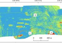
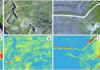
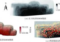
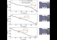
露天煤矿排土场具有地形复杂、堆存松散、异质性强等特点,长期存在会产生整体非均匀沉降、边坡失稳变形、蠕动等地质环境问题。因此,掌握排土场精确地形数据是保证其地质稳定性的基础,然而传统地形测量技术难以满足高精度需求;无人机低空摄影测量所获地形数据虽分辨率高,但受地表植被影响导致垂直精度不足。针对这一问题,提出基于可见光植被指数-植被高度回归模型的地形数据获取方法,即利用回归模型对无人机摄影测量获取的地表高程值进行修正以提高垂直精度。以宝日希勒露天煤矿外排土场北坡为研究对象,利用无人机摄影测量技术获取研究区初始地形和正射影像数据,再基于可见光建立植被指数-植被高度回归模型对初始高程值进行优化。实验表明:可见光植被指数与植被高度具有较好的相关关系,基于不同波段建立的植被指数对植被高度的估算精度存在较大差异,其中利用红绿蓝3个波段建立的植被指数EXG模型(R2=0.952)和RGBVI模型(R2=0.95)具有较高的拟合精度。结合可见光植被指数-植被高度修正模型可提高无人机摄影测量获取的地形数据精度,研究区检查点均方根误差由0.111 m提高到0.045 m。与传统GPS RTK地形测量技术相比,此方法在地形复杂处精度更高,在中小尺度上获取高精度地形数据具有较大优势。
The waste dump of opencast coal mine is characterized by complex topography,loose stacking and strong heterogeneity. The long-term existence of the drainage field will produce some geological and environmental problems such as overall non-uniform settlement,slope instability deformation and peristalsis. Therefore,the understanding on the precise topographic data of the drainage field is the basis for ensuring its geological stability. However,the traditional topographic measurement technology is difficult to meet the requirement of high precision,and the terrain data obtained from low-altitude photogrammetry of UAV is influenced by surface vegetation,resulting in insufficient vertical accuracy. To overcome this problem,a method for obtaining topographic data based on the visible-light vegetation in- dex-vegetation height regression model is proposed. The surface elevation value obtained by UAV photogrammetry is modified using regression model to improve vertical high precision. Taking the north slope of the outer dump of the Baorixile opencast coal mine as the research object,the UAV photogrammetry technique was used to obtain the initial topographic and positive image data,and the vegetation index-vegetation height regression model was established to op- timize the initial elevation value. The results show that the visible vegetation index has a good correlation with the veg- etation height,and the estimation precision of vegetation index based on different bands has difference,and the vegeta- tion index EXG model (R2 = 0. 952) and RGBVI model (R2 = 0. 95) have high precision. Using the UAV Photogram- metry technique combined with the correction model to obtain the terrain data precision of the study area,the mean square root error of checkpoint is increased from 0. 111 m to 0. 045 m. Compared with the traditional GPS RTK terrain measurement technology,this method has a higher precision in the terrain complex,and obtains high-precision terrain data in medium and small scale.
dump site;vegetation index;opencast coal mine;terrain survey;unmanned aerial vehicle ( UAV);photo- grammetry


主办单位:煤炭科学研究总院有限公司 中国煤炭学会学术期刊工作委员会
 煤炭学报
煤炭学报  2019年第12期
  在线阅读
在线阅读