• 论文
主办单位:煤炭科学研究总院有限公司、中国煤炭学会学术期刊工作委员会
基于LIDAR的矿区恢复植被高度提取方法研究
  • Title

    Extracting methods for height of restored vegetation in mining area based on LIDAR

  • 作者

    陈秋计杭梦如李继业王鑫

  • Author

    CHEN Qiuji,HANG Mengru,LI Jiye,WANG Xin

  • 单位

    西安科技大学测绘科学与技术学院

  • Organization
    College of Geomatics,Xi′an University of Science and Technology,Xi′an ,China
  • 摘要

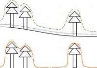
    矿区土地复垦与生态恢复是建设绿色矿山的重要内容,如何快速监测和评价生态重建效果是迫切需要解决的问题。先进的机载激光雷达测量系统(LIDAR),能够快速准确地获得矿区的植被参数信息,对现代矿山保护、环境治理和监测具有重要的意义。以某露天矿为研究对象,利用无人机雷达测量技术,获取矿区植被点云数据,然后分别采用克里金插值法、不规则三角网插值法和反距离权重插值法建立植被冠层高度模型,提取相应的树高,并将估算值与实测的样本点进行对比分析,进而探究不同插值方法对于该矿区恢复植被高度信息提取的适用性。结果发现:利用反距离权重插值法建立的冠层高度模型所提取的植被高度信息精度最高,2块样地的决定系数R2分别为0.763和0.617,均方根误差分别是0.113 m和0.130 m。其次是不规则三角网插值法,2块样地的决定系数R2分别为0.744和0.599,均方根误差分别是0.121 m和0.135 m。克里金插值法的精度较低,2块样地的决定系数R2分别是0.736和0.534,均方根误差分别是0.120 m和0.153 m。研究也发现由于2块样地地形高度不同,相对飞行高度存在差异,距离无人机的相对高度越低,采集的数据质量就越好,提取的精度就越高。研究表明无人机雷达测量技术能够获取高精度的植被点云数据,通过建模提取植被参数,指导生态环境管理,在矿区土地复垦与生态修复领域具有广泛的应用前景。


  • Abstract
    Land reclamation and ecological restoration are important contents of green mine,and how to quickly monitor and evaluate the effect of ecological reconstruction are urgent problems need to be solved.The advanced airborne LIDAR (light detection and ranging)measurement system can obtain the vegetation parameter information of the mining area quickly and accurately,which is of great significance for environmental control and monitoring.In this paper,taking an open mine as study area,the UAV-LIDAR (unmanned aerial vehicle light detection and ranging) measurement technology is used to obtain the point cloud data of vegetation,then the CHMs (canopy height model) are established with three different methods which are Kriging interpolation algorithm,TIN (Triangulated Irregular Network)interpolation algorithm and IDW (Inverse Distance Weighted) interpolation algorithm,then the heights of tree are calculated based on the CHMs.To study the applicability of different interpolation methods for vegetation height extraction in this mining area,the values of extraction are compared with the in_situ measured samples.The results show that the accuracy of IDW interpolation algorithm is the highest.The determination coefficient R2 of the two selected plots is 0.763 and 0.617 respectively,and the root mean square error RMSE is 0.113 m and 0.130 m respectively.The next is the TIN interpolation algorithm,the R2 of the two plots is 0.744 and 0.599 respectively,and the RMSE of the two plots are 0.121 m and 0.135 m respectively.For Kriging interpolation,the R2 of the two plots is 0.736 and 0.534 and the RMSE is 0.120 m and 0.153 m respectively.The search also find that the change of relative flight height caused by landform difference will affect the accuracy of tree height extraction.The research finds that UAV-LIDAR can obtain high precision point cloud data of vegetation,then vege-tation parameters can be extracted through modeling.The information about vegetation can guide ecological environment management,so,UAV-LIDAR has a wide application prospect in the field of land reclamation and ecological restoration in mining areas.
  • 关键词

    土地复垦矿区植被植被高度无人机雷达测量技术

  • KeyWords

    land reclamation ; vegetation in mining area; height of restored vegetation;UAV-LIDAR

  • 相关文章
  • 相关专题
  • 图表
相关问题

主办单位:煤炭科学研究总院有限公司 中国煤炭学会学术期刊工作委员会

©版权所有2015 煤炭科学研究总院有限公司 地址:北京市朝阳区和平里青年沟东路煤炭大厦 邮编:100013
京ICP备05086979号-16  技术支持:云智互联