
主办单位:煤炭科学研究总院有限公司、中国煤炭学会学术期刊工作委员会
Framework and thinking of transparent geological conditions for precise mining of coal
YUAN Liang1,2 ,ZHANG Pingsong1,2
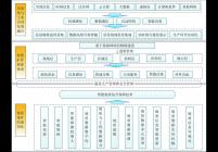
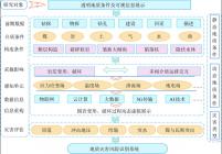
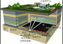
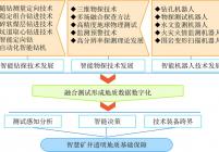
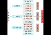
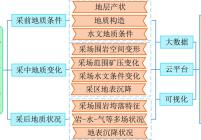
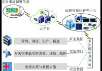
矿井透明地质条件是煤炭精准开采智慧化的重要基础。结合矿井静态地质要素大数据信息库、多灾害源全程信息感知与监测、动态地质要素虚拟现实展示、特殊地质因素动态评判与风险判识、预警等智慧模块的交互应用,从静态与动态地质模型角度提出实现煤炭精准生产全过程地质条件透明化的思路。其一,静态地质模型通过采集“空-天-地-井-孔”全方位立体化探测模式数据,融合井巷建设基础地质信息,重构地下空间地质特征数字模型,为资源、构造、井巷等静态因素评价、浏览、计算等提供基础。其二,通过动态地质模型获取掘采工程扰动效应影响下,原生静态地下空间地质条件发生变形与破坏,由此而引起的应力应变场、地质地球物理场、渗流场、温度场、浓度场等状态发生改变的参量特征;以及工程动力学作用下,生产环境周边岩层的离层、裂隙、垮落、围岩失稳、底臌、冲击地压显现、应力集中与释放、煤与瓦斯涌突、突水溃沙等多种灾害源现象的动态地质信息变化量值。特别针对动态地质模型发生与发展过程中状态及参数的显现不同,通过进一步加强多介质、多相、多态、多维、多源数据的有机融合,进行多参数联合反演,搭建井上下复合源信息监控平台,构建耦合信息、致灾因素、灾害前兆等多元信息数据库和时空四维地质信息系统,进行实时连续动态监控;并通过对静态地质模型参数注入和改造,反演地质及灾害源条件的变化状态,实现对煤层精细赋存条件、多灾害源受采掘影响致灾过程的透明化。同时,结合采掘要素对特殊地质条件进行探测与评价,从而实现整个矿井地质条件的透明重构。实施中,还需要利用物联网、云平台、大数据、人工智能、VR等技术,进行资源整合、集成和升级改造,将矿区分散的、零星的地质信息聚集起来,实现“主动感知、自动分析、智能决策”,最终为煤系资源的精准开发利用和智慧矿区的建设管理提供支撑。
Transparent geological condition is an important foundation for intelligent and precise coal mining. Combined with the interactive application of mine static geological elements such as big data information,whole process informa- tion perception and monitoring of multi-hazard sources,virtual reality display of dynamic geological elements,dynamic evaluation and risk identification of special geological elements,early warning,and other intelligent modules,the idea of realizing the transparency of geological conditions in the whole process of coal precise production is proposed from the angle of static and dynamic geological models. One of them is the static geological model,which can provide the basis for the evaluation,browsing and calculation of static factors such as resources,structure,shaft and roadway by collecting the data from “ space-sky-ground-shaft-bore-hole” all-around three-dimensional exploration mode,integra- ting the basic geological information of shaft and roadway construction,and reconstructing the digital model of geolog- ical characteristics of underground space. At the same time,under the influence of excavation disturbance,the deforma- tion and destruction of the geological conditions of original static underground space,as well as the parameter charac- teristics of the changes of stress-strain field,geological-geophysical field,seepage flow field,temperature field and con- centration field caused by the dynamic geological model are obtained. Also,under the action of engineering dynamics, the dynamic geological information change values of many kinds of disaster source phenomena such as separation,frac- ture,collapse,instability of surrounding rock, floor heave, rockburst, stress concentration and release, coal and gas gushing,water bursting and sand bursting and so on. In particular,in view of the different states and parameters during the occurrence and development of a dynamic geological model,through further strengthening the organic integration of multi-media,multi-phase,multi-dimensional and multi-source data,carrying out multi-parameter joint inversion,build- ing a multi-source information monitoring platform above and below the shaft,building a multi-source information data- base including coupling information,disaster causing factors,disaster precursors and four-dimensional geological infor- mation system in space and time,a real-time continuous dynamic monitoring is achieved. By injecting and transforming the parameters of the static geological model,the changing state of the geological and disaster source conditions can be inverted,so as to realize the transparency of the fine occurrence conditions of coal seams and the disaster process caused by the influence of mining on multiple disaster sources. More importantly,combined with the mining elements to detect and evaluate the special geological conditions,the whole mine geological conditions can be reconstructed transparently. In the process,it also needs to use the Internet of things,cloud platform,big data,artificial intelligence, VR and other technologies for resource integration,collection,upgrading and transformation. The purpose is to gather the scattered and scattered geological information in the mining area to realize “ active perception,automatic analysis and intelligent decision-making”. Finally,it provides a support for the precise development and utilization of coal re- sources and the construction and management of intelligent mining.
transparent geological conditions;framework;precise mining;intelligent mine


主办单位:煤炭科学研究总院有限公司 中国煤炭学会学术期刊工作委员会
 煤炭学报
煤炭学报  2020年第07期
  在线阅读
在线阅读